Earth and Space Sciences Regents, August 2025, question 19
Tap an image to open it full size.
What the figure shows
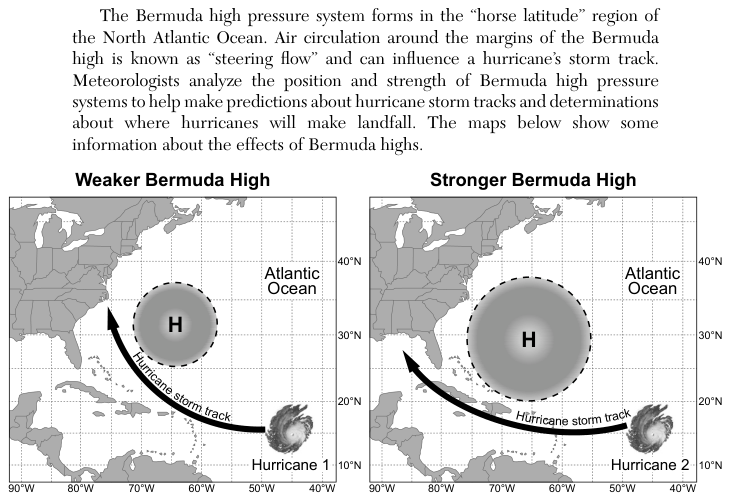
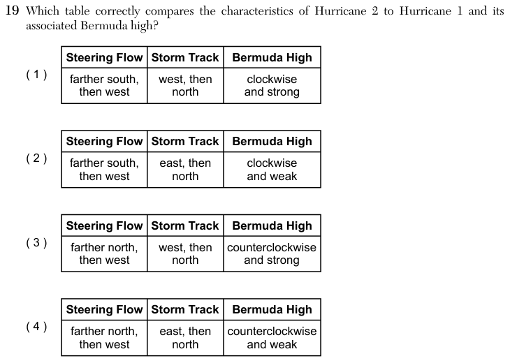
The passage says the Bermuda high pressure system forms in the horse latitude region of the North Atlantic Ocean, that air circulation around its margins is known as steering flow, and that it can influence a hurricane's storm track. Two maps of the western Atlantic (about 90 degrees west to 40 degrees west, 10 degrees north to 40 degrees north) are shown. Weaker Bermuda High: a small high (H) centered near 32 degrees north, 65 degrees west, and Hurricane 1 starting near 13 degrees north, 50 degrees west, with a curved storm track arrow that ends near the coast of the southeastern United States at about 34 degrees north. Stronger Bermuda High: a larger high centered near 30 degrees north, 66 degrees west, and Hurricane 2 starting near 14 degrees north, 48 degrees west, with a storm track arrow that ends near 26 degrees north, 88 degrees west. The four answer choices are tables with three columns: Steering Flow, Storm Track and Bermuda High. Table 1: farther south, then west; west, then north; clockwise and strong. Table 2: farther south, then west; east, then north; clockwise and weak. Table 3: farther north, then west; west, then north; counterclockwise and strong. Table 4: farther north, then west; east, then north; counterclockwise and weak.
How to think about it
Compare the two maps one feature at a time. First, follow each storm track arrow across the map, using the longitude and latitude lines. Second, note how big each high is and how far south its edge reaches. Third, recall which way air circulates around a high pressure center in the Northern Hemisphere; the Model of Generalized Planetary Wind Belts in the Troposphere shows arrows around the H symbols.
Which table correctly compares the characteristics of Hurricane 2 to Hurricane 1 and its associated Bermuda high? Steering Flow farther south, then west west, then north clockwise and strong Storm Track Bermuda High Steering Flow farther south, then west east, then north clockwise and weak Storm Track Bermuda High Steering Flow farther north, then west west, then north counterclockwise and strong Storm Track Bermuda High Steering Flow farther north, then west east, then north counterclockwise and weak Storm Track Bermuda High